
WWF makes a remarkable statement:
“The glaciers supply 8.6 million cubic metres (303.6 million cubic feet) every year to Asian rivers, including the Yangtze and Yellow rivers in China, the Ganga in India, the Indus in Pakistan, the Brahmaputra in Bangladesh and Burma's Irrawaddy.”Remarkable because to-date glaciologists have absolutely no idea how much water is contributed by mountain runoffs to downstream river users. No one really precisely knows how much is snow melt and how much ice (glacier) melt or how much monsoons contribute as runoffs to rivers like the Ganges.These are not the only problems with the WWF hysteria. The major arguments against it are discussed below:1. The operating assumption of global warmist argument is that glaciers are melting because global temperatures are rising which in turn is attributed to increased CO2 being pumped into the atmosphere as an offshoot of the industrial revolution. So higher the temperature, the more vulnerable glaciers are to melt and once they have completely melted, there would be no more water for our great rivers and their tributaries like the Ganga, Brahmaputra, Rabi; Chenab; Jhelum; Beas; Sutlej etc.
But history tells us that the cradle of Indian civilization 4,000 years ago was the Indus Valley watersheds of these same very rivers. Now if the retreat of the glaciers is only a recent phenomenon as global warming activists make them out to be, then where did the water for these rivers come from 4,000 years ago? The only way for that to happen is for the glaciers to have been in constant retreat even before the start of human history!So what have we now? It’s clear that though glaciers are currently in retreat, industrial revolution and increase in C02 in the atmosphere logically do not seem to have anything to do with it.If so, the bulk of the water has to come from somewhere and the only source that can provide such large amounts is the monsoons! The other complementary source to monsoons could be of course, seasonal snow melt.
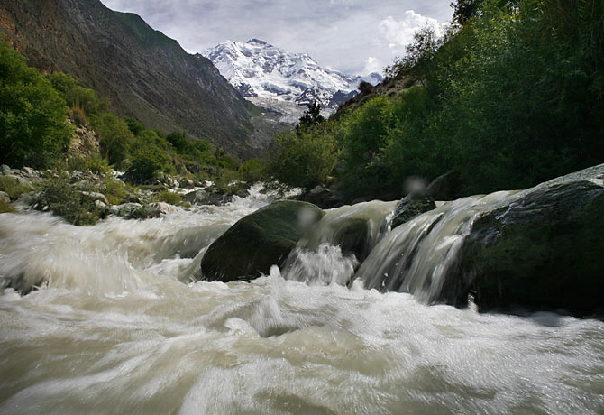
2. Besides it looks highly illogically for glacier/snow melt to contribute significantly to the river flow in India. The catchment areas of these major rivers are so enormous while the area above the snow line in comparison is relatively minute. Therefore, logically it is again only the monsoons that could provide such huge quantum of water to sustain river flows rather than smaller amounts that gets deposited as snow or larger amounts frozen by glaciers in the high mountains. This is why whenever we get deficit monsoons, we see the river depths plunging or even running dry in parts. The converse also holds true. Rivers breaking their banks and flooding the plains during excessive rains just as we experienced during the last two monsoon seasons due to the La Niña effect.
3. These climate alarmists besides argue that unless the glaciers are conserved (by reducing global temperature which in turn can be only brought about by a reduction in atmospheric CO2 levels) only then can “40% of those living in China and South Asian regions” be saved from chronic water shortages in the future.Globally there’s an estimated 1.3 billion people living in watersheds who benefit from some amount of glacier runoff. Let’s assume for a moment, no matter how hare-brained their climate mitigation solutions may look like, that these touted solutions actually bring about the desired global temperature decline. So then, will these 1.3 billion people then be spared chronic water shortages as they predicted?The problem is, cooler temperatures can only accentuate the problem of water scarcity as advancing glaciers would freeze more and water, which in turn means proportionate reduction of (whatever) the glacial runoff that these people in these watersheds are now receiving. So what will happen if glaciers disappeared altogether? Again, there would be little or no glacier runoff. So what we have here is a zero sum game which should make us wonder what all the hullabaloo of glaciers is all about.But that’s the theory. In practice, glaciers however can be considered conceptually similar to a dam. During the global cooling cycle, they lock up water by freezing it and during the global warming cycle, they release water by melting. This is precisely why glaciologists say that glaciers are never in a state of equilibrium viz. they are always either expanding or retreating in alternating natural cycles as seen by their past, historic behaviour. So during high temperatures, they melt more than usual, providing more glacial runoff while during excessive precipitation and low temperatures, they lock up water and this way moderate the impact of both droughts and floods - a kind of a climate mitigating mechanism that nature has bestowed on us.4. Further, let’s for argument sake, accept the hypothesis that glacial melt is the main source of water for rivers like the Ganges and this source is endangered because glaciers are rapidly melting. Accordingly, rising water level of rivers (the outcome) should easily validate this hypothesis. Then why is it there is no such evidence of this in the real world? On the other hand, river height strongly correlates with the intensity of the monsoon.5. Additionally, multi-decadal trend analysis indicates that relatively lesser precipitation (rain and snow) has been falling on the Central and Eastern Himalaya. The El Niño induced drought of 2009-2010 for example saw the lowest recorded rainfall in 37 years. As a result, many of the glaciers in that region suffered significant retreats. In contrast, glaciers in the Western Himalaya, which are fed by winter precipitation from Westerlies (winds from the west), despite the drought, were found to be less sensitive to changes in the monsoon; some even found advancing.So the glaciers of the Western Himalayas are not so much a conservation problem whereas the key determinant of glacier health in Central & Eastern Himalayas appears to be the summer monsoon. The monsoon, which is the engine of the weather cycle in the region and – of India’s agricultural economy displays strong multi-decadal variations, tending to follow roughly a 30 year dry-wet oscillation pattern that in turn, strongly correlates with a natural, oceanic climatic phenomenon known as the Pacific Decadal Oscillation (PDO). Similarly, on a shorter time scale, the El Niño Southern Oscillation (ENSO) also significantly, affects the monsoons but on a 3-5 year, dry-wet alternating cycle.

Besides, whenever the PDO is positive, historical trend analysis shows that El Niños (that brings lack of rain and droughts to India) are more in relative frequency and of relative higher intensity than its reverse phenomenon, the La Niña. Likewise when the PDO is negative, the La Niñas are found more in relative frequency and of relative higher intensity. The PDO turned negative around 2007, which means we can expect or the next 25-30 years more bountiful rainfall as compared to the past for India similar to what we are experiencing for the last two years due to an on-going multi-year La Niña. Consequently, the retreat of glaciers in Central & Eastern Himalayas should be at least checked, if not actually advance during the next 25-30 years.6. The World Glacier Monitoring Service is an auspice of ICSU (WDS), IUGG (IACS), UNEP, UNESCO, WMO working in close collaboration with the U.S. National Snow and Ice Data Center (NSIDC) and the Global Land Ice Measurements from Space (GLIMS) initiative. The WGMS run the Global Terrestrial Network for Glaciers (GTN-G) in support of the United Nations Framework Convention on Climate Change (UNFCC). It is interesting what they say on the subject - a few extracts are given below:a. The reasons for the cyclical nature of the ice ages, so-called Milankovitch cycles, with dominant periods of 23,000, 41,000, 100,000 and 400,000 years (Milankovitch 1930), are mainly to be found in the variation of the earth rotational parameters.b. Further influences include the variability of solar activity, the latitudinal position of the earth’s continents, the chemical composition of the atmosphere, the internal dynamics of the climate system, as well as volcanic eruptions and impacts of meteorites of extreme dimensions.c. The overall glacier retreat after the Last Glacial Maximum and extending to the early Holocene is very much in line with the global warming (Solomina et al. 2008). The major glacier re-advances around 8,200 years ago were related possibly to a change in the thermohaline circulation of the ocean in the NorthAtlantic and North Pacific, and a subsequent cooling, due to the outburst of the Lake Agassiz on the North American continent (Solomina et al. 2008). By contrast, the gradual re-advance of tropical glaciers from their small extents, or even absence, in the early to mid Holocene was probably a result of increasing humidity (Abbott et al. 2003).d. The periods of simultaneous glacier advances around the world, peaking in the late Holocene in the Northern Hemisphere and in the early Holocene in the Southern Hemisphere, as well as the glacier maximum extents towards the end of the LIA are attributed to changes in solar irradiance, in dependence on the sun’s activity and the earth’s orbit, and also to the effects of volcanic eruption, internal dynamics of the climate system (Grove 2004, Solanki et al. 2004, Koch and Clague 2006)
e. ENSO appears to be fundamentally correlated to the south Asian monsoon and hence to snow and ice accumulation in the Himalaya (Bush, 2002). On longer timescales, the Pacific Decadal Oscillation and centennial climate variability also appear to have significant global signatures in temperature and precipitation, and will also play a role in crysopheric dynamics at the Earth’s surface.f. The glacier moraines formed during the end of the (Little Ice Age) LIA, between the 17th and the second half of the 19th century, mark Holocene maximum extents of glaciers in most of the world‘s mountain ranges. From these positions, glaciers around the globe have been shrinking significantly, with strong glacier retreats in the 1940s, stable or growing conditions around the 1970s, and again increasing rates of ice loss since the mid 1980s. On a shorter time scale, glaciers in various mountain ranges have shown intermittent re-advances. Looking at individual fluctuation series, a high variability and sometimes contradictory behaviour of neighbouring ice bodies are found which can be explained by the different glacier characteristics. The early mass balance measurements indicate strong ice losses as early as the 1940s and 1950s, followed by a moderate ice loss between 1966 and 1985, and accelerating ice losses until present.New Research debunks Doomsday Himalayan Water Shortage Predictions

A new research paper debunks the doomsday scare of mass water shortages due to receding Himalayan glaciers. Rivers will not run dry as upto 80-90% of river water are contributed by the monsoons. Here’s the paper published in Scientific American:From the Andes to the Himalayas, scientists are starting to question exactly how much glaciers contribute to river water used downstream for drinking and irrigation. The answers could turn the conventional wisdom about glacier melt on its head.A growing number of studies based on satellite data and stream chemistry analyses have found that far less surface water comes from glacier melt than previously assumed. In Peru's Rio Santa, which drains the Cordilleras Blanca mountain range, glacier contribution appears to be between 10 and 20 percent. In the eastern Himalayas, it is less than 5 percent."If anything, that's probably fairly large," said Richard Armstrong, a senior research scientist at the Boulder, Colo.-based Cooperative Institute for Research in Environmental Sciences (CIRES), who studies melt impact in the Himalayas."Most of the people downstream, they get the water from the monsoon," Armstrong said. "It doesn't take away from the importance [of glacier melt], but we need to get the science right for future planning and water resource assessments."The Himalayan glaciers feed into Asia's biggest rivers: the Indus, the Ganges and the Brahmaputra in India, Pakistan and Bangladesh, and the Yellow and Yangtze rivers in China. Early studies pegged the amount of meltwater in these river basins as high as 60 or 70 percent. But reliable data on how much water the glaciers release or where that water goes have been difficult to develop. Satellite images can't provide such regular hydrometeorological observations, and expeditions take significant time, money and physical exertion.New methods, though, are refining the ability to study this and other remote glacial mountain ranges. Increasingly, scientists are finding that the numbers vary depending on the river, and even in different parts of the same river.
Creeping hyperbole

"There has been a lot of misinformation and confusion about it," said Peter Gleick, co-director of the California-based Pacific Institute for Studies in Development, Environment and Security. "About 1.3 billion people live in the watersheds that get some glacier runoff, but not all of those people depend only on the water from those watersheds, and not all the water in those watersheds comes from glaciers. Most of it comes from rainwater," he said.A key step forward came last year when scientists at Utrecht University in the Netherlands, using remote sensing equipment, found that snow and glacier melt is extremely important to the Indus and Brahmaputra basins, but less critical to others. In the Indus, they found, the meltwater contribution is 151 percent compared to the total runoff generated at low elevations. It makes up about 27 percent of the Brahmaputra -- but only between 8 and 10 percent for the Ganges, Yangtze and Yellow rivers. Rainfall makes up the rest.That in itself is significant, and could reduce food security for 4.5 percent of the population in an already-struggling region. Yet, scientists complain, data are often inaccurately incorporated in dire predictions of Himalayan glacial melt impacts."Hyperbole has a way of creeping in here," said Bryan Mark, an assistant professor of geography at Ohio State University and a researcher at the Byrd Polar Research Center.
Mark, who focuses on the Andes region, developed a method of determining how much of a community's water supply is glacier-fed by analyzing the hydrogen and oxygen isotopes in water samples. He recently took that experience to Nepal, where he collected water samples from the Himalayan glacier-fed Kosi River as part of an expedition led by the Mountain Institute.Based on his experience in the Rio Santa -- where it was once assumed that 80 percent of water in the basin came from glacier melt -- Mark said he expects to find that the impact of monsoon water is greatly underestimated in the Himalayas.Jeff La Frenierre, a graduate student at Ohio State University, is studying Ecuador's Chimborazo glacier, which forms the headwaters of three different watershed systems, serving as a water source for thousands of people. About 35 percent of the glacier coverage has disappeared since the 1970s.La Frenierre first came to Ecuador as part of Engineers Without Borders to help build a water system, and soon started to ask what changes in the mountain's glacier coverage would mean for the irrigation and drinking needs of the 200,000 people living downstream. Working with Mark and analyzing water streams, he said, is upending many of his assumptions.
Doomsday descriptions don't fit

"The easy hypothesis is that it's going to be a disaster here. I don't know if that's the case," La Frenierre said. He agreed that overstatements about the impacts are rampant in the Himalayas as well, saying, "The idea that 1.4 billion people are going to be without water when the glaciers melt is just not the case. It's a local problem; it's a local question. There are places that are going to be more impacted than other places."Those aren't messages that environmental activists will likely find easy to hear. Armstrong recalled giving a presentation in Kathmandu on his early findings to a less-than-appreciative audience."I didn't agree with the doomsday predictions, and I didn't have anything that was anywhere near spectacular," Armstrong said. But, he added, "At the same time, it's just basic Earth science, and we want to do a better job than we have been."The more modest numbers, they and other scientists stressed, don't mean that glacier melt is unimportant to river basins. Rather, they said, they mean that the understanding of water systems throughout the Himalayan region must improve and water management decisions will need to be made at very local levels."We need to know at least where the water comes from," Armstrong said. "How can we project into the future if we don't know where the water comes from now?"
No comments:
Post a Comment